


Amateur radio is a hobby of mine. Actually signal processing is my hobby, amateur radio is one way to translate the hobby into something tangible. I've been working on a program that will capture NOAA weather images from the NOAA satellites overhead. This is one part of a larger system that includes an antenna pointing and satellite tracking system (completed) and a self contained software defined radio system (in progress). This little phase of the project was to write the software that turned the data into something fun - namely, a picture.
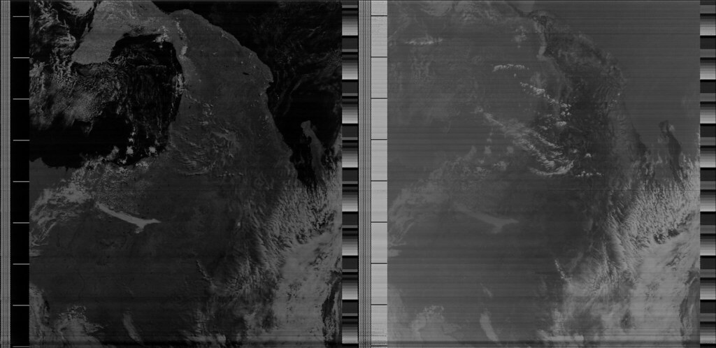
Below is the captured image of a NOAA APT slow scan picture transmission from a satellite pass over north america. The top of the screen is to the south, Baja is on the right, Gulf of Mexico on the left. The left frame is the visible spectrum and the right is infrared.
The satellite transmission is FM modulated on about 137 MHz. A radio front end performs the FM demodulation and translation to baseband and outputs the AM modulated subcarriers to my computer. My software streams in the AM modulated sample stream, demods the AM signal, finds the sync pulses and frames/decodes the image, and ultimately displays the result to the computer screen.
I need to fine tune the filter design as well as design a more intelligent coloring algorithm but all in all the features are pretty good and landmarks are obvious. When I get this done I will write the FM demodulator block so that no external radio equipment is required other than the basic RF front end; that is, complete the software defined radio block, which means no more handheld transceiver to do the FM demod.
When I get a decent antenna put together I will mount it on the tracking system I built and put the whole system operation together into a video.
The decoder software took longer than I thought it would but it did not require drinking (per Sparky's saturday night thread)
The "fun" part about this software is that it decodes in real time. That is, the image appears on the screen as it is received from the satellite. Typically people record the AM part and then run it through off the shelf decoder software that spits out an image. I wanted to be able to see it in real time - chirp by chirp.
The images are high resolution though this one doesn't really show it because of the photo hosting site. Generally they are 2080 pixels wide by however long you can receive the signal.
|
|

Results 1 to 14 of 14
Thread: Another hobby thread
-
02-07-2013, 12:04 PM #1
Another hobby thread
Last edited by mslman71; 02-07-2013 at 12:12 PM.
2 + 2 = 5 (for extremely large values of 2)
Try SCE to AUX
-
02-07-2013, 12:22 PM #2Lifetime Member

- Join Date: Aug 2006
- Location: San Diego, California, United States
- Posts: 34,794
- Rep Power: 232216


Let me see if I understand this.
The satellite beams the image down to earth and anyone with this equipment and get the image?
Obviously anyone can see the military possibilites here so i assume the encode the military messages somehow or do they just use equipment that is not available on the civilian market at any cost?
-
02-07-2013, 12:30 PM #3Registered User

- Join Date: Jul 2012
- Location: Colorado Springs, Colorado, United States
- Age: 47
- Posts: 1,168
- Rep Power: 3229
the quality and resoultion wouldn't be benefical to anyoneOriginally Posted by crupiea Dave
Dave
-
02-07-2013, 12:34 PM #4^ thisOriginally Posted by OutdoorsinCO
2 + 2 = 5 (for extremely large values of 2)
Try SCE to AUX
-
-
02-07-2013, 01:08 PM #5Lifetime Member
- Join Date: Aug 2006
- Location: San Diego, California, United States
- Posts: 34,794
- Rep Power: 232216
what if an industrious person had unlimited funds to purchase better equipment?Originally Posted by OutdoorsinCO
-
02-07-2013, 01:09 PM #6The limitation is on the satellite end.Originally Posted by crupiea
2 + 2 = 5 (for extremely large values of 2)
Try SCE to AUX
-
02-07-2013, 01:13 PM #7Lifetime Member
- Join Date: Aug 2006
- Location: San Diego, California, United States
- Posts: 34,794
- Rep Power: 232216
what would keep this person from selecting a different sattelite?Originally Posted by mslman71
-
02-07-2013, 01:20 PM #8There are a variety of transmission systems and resolutions. NOAA has high resolution format, HRPT, which is about a km of resolution, and anyone with the right equipment can get the data, but again, these aren't that useful, especially since you're at the mercy of the timing of the satellite pass. I don't know what other signals are open (not encrypted). The higher the resolution the larger the required bandwidth and the higher the transmission frequency. It gets to be more and more expensive to get the data down. The APT format is slow scan, meaning in this case it only sends down 1 line every half second. Getting down to the meter level resolution, any any stage of the pipe, isn't trivial.Originally Posted by crupiea
2 + 2 = 5 (for extremely large values of 2)
Try SCE to AUX
-
-
02-07-2013, 01:29 PM #9Lifetime Member
- Join Date: Aug 2006
- Location: San Diego, California, United States
- Posts: 34,794
- Rep Power: 232216
makes sense, thanksOriginally Posted by mslman71
-
02-07-2013, 01:50 PM #10Registered User
- Join Date: Jul 2012
- Location: Colorado Springs, Colorado, United States
- Age: 47
- Posts: 1,168
- Rep Power: 3229
There are government restrictions in place to limit folks to a certain resolution. The cost/technology ratio is too high for the average person. Even the common commercial sensors out there, WorldView, Terrasar X, COSMIC, etc are not ones the able body person can get, or cost. Trust me, the govt pays a pretty penny for them. Especially during a disaster area.Originally Posted by crupiea
Dave
-
02-07-2013, 02:02 PM #11Master Roshi

- Join Date: Dec 2008
- Location: Oregon, United States
- Posts: 45,599
- Rep Power: 1292381
Interesting! I was just reading about SSTV yesterday.
★DSC★
★MISC Cologne Crew★
★4200 cals a day crew★
★Squat Booty Sorority Fan Club★
★Forum Member #109,914,313★
► ► ►Dirty South Crew gear: https://www.zazzle.com/s/thedirtysouthlifts ◄ ◄ ◄ (Proceeds go to children's charities)
-
02-07-2013, 02:58 PM #12Lifetime Member
- Join Date: Aug 2006
- Location: San Diego, California, United States
- Posts: 34,794
- Rep Power: 232216
I always wondered about stealth technology.Originally Posted by OutdoorsinCO
Of course they are elusive to radar but how would we know that unless we had some super secret radar that could tell the difference?
of course if someone else learned that radar technology then the whole point of stealth would be over.
There are very few people in the world producing such technologies and as stuff gets more complex the fewer people are going to own it.
Reminds me of that book by Oleg Kalugin, kgb station chief in washington d.c. and new york city.
he lays out how intelligence services go about gathering little bits of information to piece together a bigger picture.
-
-
02-07-2013, 04:23 PM #13Registered User
- Join Date: Jul 2012
- Location: Colorado Springs, Colorado, United States
- Age: 47
- Posts: 1,168
- Rep Power: 3229
What do you mean by stealth technology and being elusive to radar?Originally Posted by crupiea
Dave
-
02-07-2013, 05:12 PM #14There's nothing particularly magical about the RF/microwave side of any of these systems, in the sense that the technology to get signals up and back is not horrifically expensive.Originally Posted by OutdoorsinCO
2 + 2 = 5 (for extremely large values of 2)
Try SCE to AUX


Similar Threads
-
Random Comments Thread
By Botika in forum Female Misc.Replies: 8037Last Post: 04-02-2013, 02:38 PM -
Well, I took up bodybuilding after my Ban; another quality thread by STILLSKINNY
By SockPupper in forum Misc.Replies: 46Last Post: 01-04-2007, 10:48 PM -
I hate to be a bitch and make another 5x5 thread
By Nitronic in forum Powerlifting/StrongmanReplies: 3Last Post: 10-25-2006, 11:03 PM
Bookmarks